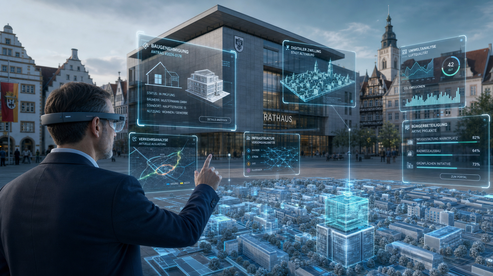
Augmented Reality in Municipalities | Town Hall in 3D: How Spatial Computing is Changing the Tedious Trip to the Government Office Forever – Image: Xpert.Digital
Experience development plans live: How augmented reality is revolutionizing citizen participation
The walkable city: How digital twins are beaming our communities into the future
Local governments face a formidable, twofold challenge: they are expected to make processes more digital, transparent, and citizen-friendly, while simultaneously grappling with tight budgets and a severe shortage of skilled workers. While digitalization has often simply meant converting paper forms into rigid PDFs or linear web portals, a technology is now emerging that could break this bottleneck: spatial computing. The merging of the digital data world and physical space – driven by augmented reality (AR) and virtual reality (VR) – offers public authorities entirely new tools. Whether it's training new specialists in virtual space, equipping municipal staff with smart glasses, or creating walkable digital twins of entire city districts for tangible citizen participation: the "town hall in 3D" is no longer distant science fiction, but is becoming a strategic necessity. But how practical are these immersive technologies in the strictly regulated daily operations of public administration, and how can hurdles related to data protection and infrastructure be overcome? A deep dive into the future of local government.
Spatial Computing in Municipalities: When the Administration Enters the Space
Between screen management and an immersive future: Why the town hall needs to learn 3D before it becomes irrelevant
Local governments face a fundamental dilemma. They are expected to become faster, more citizen-oriented, and more efficient – and have been doing so for decades with the same tools: the screen, the keyboard, and linear form paths. Digital transformation has undoubtedly changed this apparatus, replacing paper with PDFs and the trip to the office with a click in the portal. But the core of the problem remains untouched: Digital processes operate detached from the physical space in which municipal action actually takes effect. A building permit pertains to a specific plot of land. Traffic planning alters real streets. A participatory process is meant to engage people who can barely grasp the meaning of visualizations in documents. This structural mismatch between the digital reality of administration and the physical world is the starting point for a technology that is currently being systematically brought into focus for municipal innovation: spatial computing.
Technology at a turning point: What spatial computing really is
The term "spatial computing" sounds like marketing jargon from Silicon Valley, but it describes a tangible technological paradigm. At its core, it's about connecting two worlds: the digital world of information and the physical space where people live and work. Specifically, spatial computing encompasses the combination of augmented reality (AR), virtual reality (VR), artificial intelligence, sensor data, and spatial tracking into an integrated experiential environment.
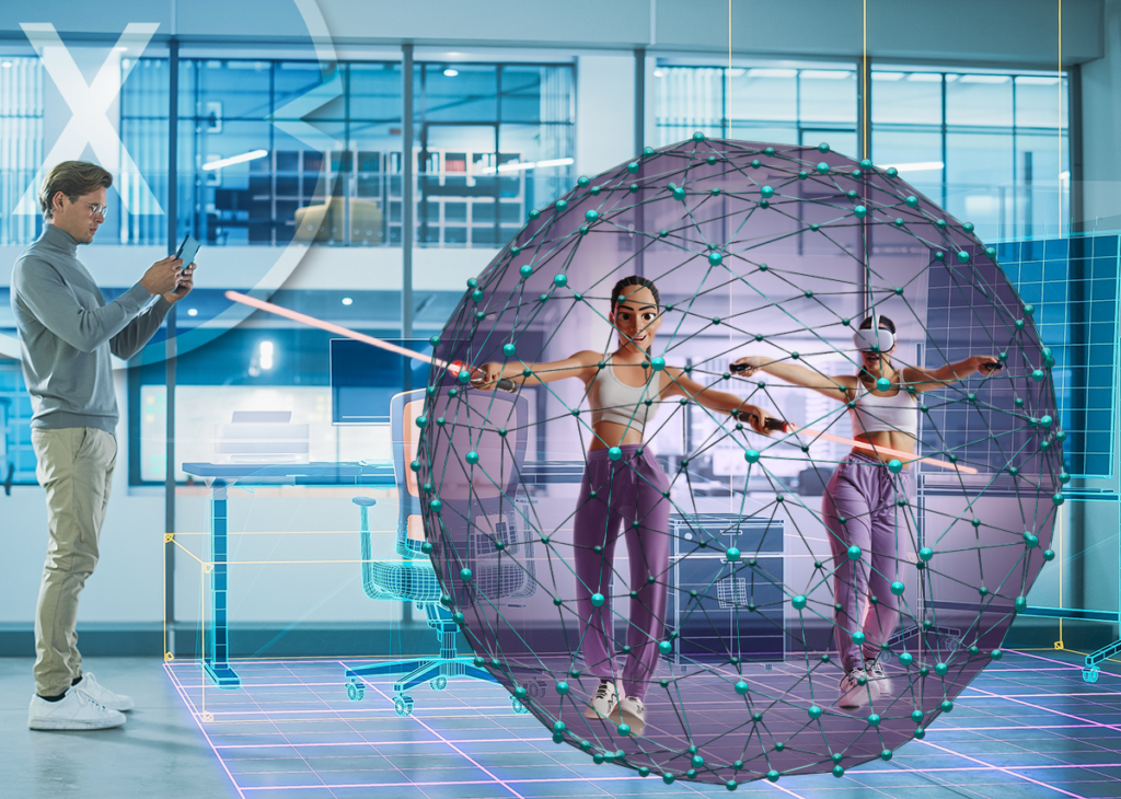
Augmented Reality (AR) enhances the real world with digital content – a city engineer looking at a street through AR glasses simultaneously sees superimposed utility lines, development plans, or pollution measurements. Virtual Reality (VR), on the other hand, completely replaces the physical environment with a computer-generated, three-dimensional world – a citizen who wants to virtually walk through a planned new building on their street can do so with a VR headset without leaving their home. Extended Reality (XR) is the umbrella term for the entire spectrum of these technologies, ranging from complete virtual immersion to minimally augmented reality.
What fundamentally distinguishes spatial computing from the previous understanding of digitalization is this: information no longer rests passively in databases or on screens, but is actively projected into the space where it is needed. The computer disappears as a device and appears as an intelligent layer over reality. Gartner has already identified spatial computing as one of the ten most important technology trends of 2025; Deloitte sees it as a key technological development line for the second half of this decade.
Market trends speak volumes. Various analysts estimate the global spatial computing market in 2025 to be between just under four billion US dollars (narrow definition of the market segment) and over 185 billion US dollars (broad definition including related technologies). Regardless of the chosen definition, all forecasts agree on one point: the growth rate is exceptional. By 2030, analysts expect annual growth rates between 21 and 43 percent, with a market volume that could exceed the trillion-dollar mark by 2034. This is not a niche technology experiment, but a structural transformation of human-computer interaction that is taking on secular dimensions.
The municipal context: Under what conditions do municipalities need innovations?
To realistically assess the added value of spatial computing for municipalities, one must understand the initial situation. Municipal administrations in Germany are simultaneously under multiple systemic pressures that increasingly challenge their ability to act.
The shortage of skilled workers is the most pressing structural challenge. According to current projections, around 731,000 public sector positions will remain unfilled by 2030. Already, an estimated one-third of all public sector employees will retire within the next ten years. The younger generation is less likely to choose a career in public administration – and when they do, they have clear expectations of modern working conditions that reflect the standards of the private sector. A public authority that uses forms from the turn of the millennium and rigid desktop systems will structurally lose out in the competition for talent.
Added to this is the pressure to cut costs. The budget situation of most German municipalities is strained; fiscal leeway for expensive experiments is limited. Paradoxically, this very pressure is an argument for technological innovation: studies show that up to 64 percent of working hours in public administrations could be automated. Spatial computing can not only make routine processes more efficient, but also enable knowledge-intensive tasks – inspection, planning, training – with significantly less personnel.
The third challenge is societal in nature: the increasing frequency of crises and rising demands on the responsiveness of public administration. Whether extreme weather events, infrastructure damage, or supply shortages – municipalities must make faster decisions, coordinate better, and make their measures transparent to an increasingly informed and critical public. These are precisely the conditions under which immersive visualization and spatial decision support unfold their greatest added value.
This constellation – skills shortage, budgetary pressure, and increasing complexity – is the fertile ground in which spatial computing in municipal administration should be discussed not as an optional upgrade, but as a strategic necessity. The German Association of Municipalities and Districts (KGSt) recognized this and, in 2025, explicitly launched the Spatial Computing Innovation Circle and published KGSt 6/2025 to open this space for discussion to municipalities.
Public participation in the community: From flyers to a walkable vision
One of the most practically compelling applications of AR and VR in municipalities is citizen participation in planning projects. The traditional approach to municipal participation is characterized by information events in overcrowded community halls, public consultation plans that most citizens cannot read, and visualizations on A3 printouts that bear little resemblance to reality. Decisions about urban districts, traffic patterns, or new development areas are made in such a way that many affected individuals only understand the planned interventions when the bulldozers arrive.
AR-based participation formats break this pattern. Citizens can walk through their street with a tablet or AR glasses and simultaneously have real-time information and visualized planning scenarios superimposed directly onto their real-world surroundings. Anyone wanting to know how a planned high-rise building would change the sunlight on their street, or what a new bike path at the intersection would look like, sees this not on an abstract plan, but in a walkable digital overlay of their real environment.
The city of Hamm has already tested this approach: The "Lippeaue Experience" app uses AR technology to make nature and the environment digitally accessible – a municipal example demonstrating how accessible and effective AR applications can be. VR applications go even further: They invite citizens to immerse themselves in a complete simulation of the future district, to walk through the planned neighborhood, and to gain impressions that go beyond any floor plan. CGI describes this approach with the image of the metaverse as an expanded democratic space: Making construction projects tangible in this way demonstrably increases acceptance, strengthens community spirit, and undermines potential resistance to such measures.
Participation thus becomes more inclusive. People who cannot read plans, people with limited mobility who cannot attend information events, or non-German-speaking citizens who rely on written materials – they can all benefit from spatial, intuitive visualizations that significantly reduce language and educational barriers.
Digital twins and urban planning: The city as a simulable object
In urban planning, a related technology has already taken concrete form: the Urban Digital Twin. This is a continuously updated, three-dimensional computer simulation of a city or district that integrates buildings, streets, green spaces, traffic flows, energy flows, and social interactions as data layers.
Since 2021, Hamburg, Leipzig, and Munich have been jointly developing urban digital twins as part of the Connected Urban Twins (CUT) cooperation project. The project combines urban data from a wide variety of sources to create realistic representations of cities and enables the simulation of what-if scenarios: How does traffic change when a main road is closed to cars? How do heat islands develop when trees are planted? Previously, these questions could only be answered empirically after the measure was implemented – digital twins make them simulable in advance.
Stuttgart is systematically expanding its Urban Digital Twin to address municipal challenges such as sustainable mobility, urban development, housing shortages, climate change, and the energy transition. The city utilizes DIN SPEC 91607, published in 2024 as a standardization framework for digital twins in cities and municipalities – a sign that the technology has moved from the experimental phase to standardized infrastructure planning. Herrenberg in Baden-Württemberg has also had a digital twin for spatial planning since 2019, which is continuously updated using sensor data.
Spatial computing adds a crucial accessibility dimension to this development. A digital twin as a database project is of little use if it is only readable by technically skilled planners. AR and VR interfaces make the information stored in the twin accessible and tangible – for experts, but also for citizens, city councils, and the media. The transition from abstract data structures to immersive urban planning is therefore not solely a question of technology, but of democratizing planning knowledge.
Education and knowledge transfer: VR as an answer to the loss of expertise
Demographic change in public administration is not only creating a quantitative staffing shortage, but also a massive loss of tacit knowledge. Experienced clerks, engineers, and specialists are retiring, taking with them decades of accumulated practical knowledge – knowledge that isn't written in any manual and is difficult to formalize. This is precisely where VR unfolds its strategically important potential.
VR simulations make it possible to recreate real-world work situations in controlled, risk-free, and repeatable virtual environments. A trainee in the civil engineering department can practice pipe-laying work under various soil conditions and weather conditions in a VR cockpit before their first visit to a real construction site. A new employee in the vehicle registration office can navigate complex, nested administrative procedures in a virtual simulation without jeopardizing real applications. Studies from the private sector show that VR-based training significantly increases learning speed and leads to better long-term retention than traditional training formats.
This is attractive for municipalities in several respects. Firstly, training costs can be significantly reduced: no travel expenses, no booked seminar rooms, no downtime for entire departments. Secondly, the knowledge of the retiring generation can be systematically transferred into VR applications – as an interactive repository of experience instead of as static PDF documentation. The KGSt Innovation Circle Spatial Computing has explicitly defined this qualification as one of its priority application areas.
Furthermore, VR training has an underestimated impact on employer attractiveness. Young professionals who have been exposed to modern work tools elsewhere perceive an administration that invests in training and uses new technologies as a more attractive employer. In this sense, spatial computing is not only a productivity tool but also an instrument of employer branding.
🗒️ Xpert.Digital: A pioneer in the field of Extended and Augmented Reality

Finding the right Metaverse agency, planning office, or consulting firm - Image: Xpert.Digital
🗒️ Finding the right Metaverse agency, planning office, or consulting firm – Search and search: Top Ten Tips for Consulting & Planning
More information here:
Spatial computing for the city: From clipboard to AI smart glass solution
Administrative work in the field: AR as an extended desk
The traditional separation between office work and field service is deeply ingrained in municipal administration. Field service employees who assess road damage, inspect green spaces, or check building permits on-site are often poorly equipped technically: a clipboard, a smartphone, and at best a poorly optimized mobile app. Relevant information—as-built plans, permit histories, sensor data—is available in the office, but not at the point of action.
AI smart glasses and AR-enabled tablets can overcome this structural break. A civil engineer inspecting a reported water main can instantly view the current pipe layout via AR glasses, take georeferenced photos of the damage, and upload them directly to the management system – without returning to the office and without data loss through manual entry. Telekom MMS describes this principle precisely: AI smart glasses are not a gadget, but a new interface that provides context-sensitive information, freeing up hands and eyes for the actual work.
In this context, spatial computing can be understood as the operating system for the smart city. Information no longer flows from the real world to the office and back to reality after analysis, but is available in real time wherever it is needed. For the operations coordinator in a disaster relief scenario, this means that in the VR command center, they not only see symbols on a map, but can enter a three-dimensional representation of the affected area, position resources, and interact spatially with other emergency responders. Japan already uses VR simulations for earthquake and tsunami drills; the USA uses AR for firefighter training and emergency management.
Budget, key figures and communication: When numbers take center stage
One of the most remarkable and simultaneously most underestimated applications of spatial computing in local government lies in data visualization. Budget figures, process maps, energy flows, demographic trends – all this information is currently presented in two-dimensional charts and tables that are difficult to understand even for experts.
3D visualizations fundamentally change this. When a city council experiences budget allocation as a walkable, three-dimensional city model, where building heights represent investment levels and colors signal priorities, an intuitive understanding emerges that no spreadsheet can generate. When citizens can "walk" through their city's planned energy infrastructure in a VR application, public understanding of municipal decisions improves in a way that is politically relevant.
Internal communication also benefits. The transition from linear video conferences to spatial virtual meeting rooms, where colleagues are present as three-dimensional avatars and collaborate on documents, maps, or models, transforms the quality of collaboration. In its contribution to KGSt publication 6/2025, the city of Hamm explicitly describes virtual meetings without a meeting room and off-site appointments without travel as real-world scenarios that are already technically feasible. For municipalities with distributed locations, for inter-municipal collaborations, or for crisis teams that need to convene at short notice, this is not a vision of the future, but rather an operational reality.
The question of profitability: Between investment and return on investment
Every technology evaluation for the public sector must honestly address the question of cost-effectiveness. Acquiring AR/VR hardware, developing customized administrative applications, and building the necessary digital infrastructure are expensive. For municipalities with tight budgets, this poses a serious obstacle.
Specific cost structures vary considerably depending on the use case. Simple AR applications for tablet-based civic engagement range from single-digit to low double-digit thousand euros; complete VR training environments for educational purposes can quickly lead to six-figure investments. In addition, there are ongoing costs for hardware maintenance, software updates, training, and technical support. Cloud-based solutions can lower the barrier to entry by enabling hardware scalability and making licensing costs more variable.
The decisive factor, however, is not the investment amount, but the return on investment over a medium-term horizon. A VR training environment that serves several hundred trainees annually, eliminating travel costs, reducing downtime, and improving learning outcomes, pays for itself within a few years. An AR-supported participation format that reduces resistance to a municipal construction project and thus shortens planning and legal processes has a fiscal value that can far exceed the initial investment.
According to a study by IDG Research Services and PTC, almost 75 percent of German companies are already using or planning to use AR or VR – and 77 percent report that these projects are achieving the desired success. A third of the surveyed companies have also opted for remote assistance applications, where AR-supported remote assistance significantly increases the efficiency of field service operations. While these experiences from the private sector cannot be directly transferred to public administration, they provide important benchmarks for municipal cost-benefit analyses.
Crucial for municipal practice is the principle of inter-municipal cost-sharing logic, which the KGSt explicitly pursues with its innovation circle: If ten municipalities jointly develop a VR training environment for civil engineering and share the costs, the burden for each individual municipality drops to one-tenth. This model of collaborative infrastructure use is proven in the municipal sector – and particularly attractive for spatial computing because the development costs are high, but the economies of scale are considerable.
Data protection and ethics: The vulnerabilities of immersive technologies
No honest analysis of spatial computing in local government can ignore the data protection and ethical challenges. They are real, complex, and in some respects still unresolved.
AR technologies, which use cameras and sensors to capture the physical environment, continuously generate data about people, spaces, and behaviors. VR environments collect movement data, eye movements, and physiological responses from their users, which can allow sensitive inferences to be drawn about health, attention, or emotional states. The General Data Protection Regulation (GDPR) is, in principle, applicable to these technologies, but its practical implementation is complex: The principle of data minimization clashes with the technical requirement to process extensive sensor data for the applications to function.
A particularly critical point is camera-based environmental mapping in public spaces. AR systems that scan outdoor areas and capture images of people who have not consented to data processing are problematic in relation to fundamental rights to privacy and informational self-determination. Warnings from civil rights organizations about the potential for misuse of smart glasses with facial recognition capabilities—an open letter from the American Civil Liberties Union (ACLU) and other organizations to Meta explicitly opposes the possibility of anonymously identifying strangers in public spaces—are also relevant for the municipal use of AR technologies.
For municipalities, this results in a clear course of action: Privacy by Design must be anchored not as a subsequent compliance task, but as a fundamental principle of every AR/VR implementation. This means technical and organizational measures such as local data processing instead of cloud transfer, strict purpose limitation of collected data, deletion concepts, transparency obligations towards data subjects, and the early involvement of municipal data protection officers in project processes. Municipalities that take this dimension seriously not only establish legal safeguards – they create the trust that will sustain the long-term social acceptance of immersive administrative technologies.
The use of XR technologies requires particular sensitivity towards vulnerable population groups: people with visual impairments, older citizens, or those with cognitive disabilities can be excluded by poorly designed immersive applications instead of benefiting from them. Inclusion must be treated as a design principle, not as an afterthought.
Infrastructure as a bottleneck: What's missing for spatial computing to work
Spatial computing requires a high-performance digital infrastructure, which – despite significant progress – is not yet available nationwide in Germany. VR streaming applications require stable, low-latency broadband connections; AR applications in the field depend on reliable mobile network coverage. Both remain a problem in rural and structurally weak regions.
Added to this is the challenge of technical integration. Municipal IT infrastructures have grown organically over time, are heterogeneous, and often suffer from a lack of interoperability. AR/VR applications that rely on real-world data from municipal systems—building data, utility plans, budget information—must communicate with these legacy systems. In many cases, this requires complex interface development and presupposes that municipal data pools are structured, accessible, and up-to-date. Without open data standards and consistent data maintenance, spatial computing remains a visual overlay on poor-quality data—which is of little use and, in the worst case, leads to misinformation.
The hardware situation is also changing. Early VR headsets, like the early Oculus devices, were bulky, expensive, and unsuitable for continuous professional use. Development is moving towards lighter, cheaper, and more robust devices. Apple Vision Pro, MetaQuest, and competing systems are driving this process; smart glasses like the Ray-Ban Meta collaborations demonstrate that the form factor problem is solvable. For municipal procurement, this means that those who start with pilot projects today will be able to rely on significantly more mature and affordable hardware in three to five years – an argument for an early start with a limited scope and a strong learning curve.
Strategic recommendations: How municipalities can make the initial steps meaningful
The preceding analysis allows for the derivation of concrete strategic recommendations for municipal decision-makers who are considering a serious entry into spatial computing.
First, municipalities should begin with pilot projects in a clearly defined, low-threshold application area. Citizen participation is particularly well-suited because the benefits are immediately tangible, data protection requirements are manageable, and the technology is sufficiently mature. A tablet-based AR overlay for an ongoing zoning plan process is a low-threshold yet effective starting point.
Secondly, inter-municipal cooperation is not a nice-to-have, but an economic necessity. The KGSt Innovation Circle Spatial Computing provides precisely the institutional framework for sharing development costs, exchanging experiences, and developing common standards. Municipalities that take advantage of this offer save resources and benefit from a collective learning curve.
Thirdly, data protection and ethics must be treated as design parameters from the outset, not as compliance burdens. The early involvement of municipal data protection officers, the selection of GDPR-compliant providers, and transparent communication with citizens about the technologies used are fundamental prerequisites for sustainable implementation.
Fourth, municipalities should pursue internal skills development in parallel with technological implementation. AR/VR technologies require not only technical expertise, but also didactic, communicative, and data protection skills. Investing in further training is not a cost factor, but rather the foundation for ensuring that the technology actually delivers its promised benefits.
Between new beginnings and realism: A sober assessment
Spatial computing is not a panacea for the structural problems of municipal administrations, and it would be unrealistic to treat it as such. The technology is still in its early stages of development in many areas; standards are lacking; and the market concentration in the hands of a few large US technology companies creates dependencies that must be strategically considered by municipalities and the German public sector.
At the same time, the analysis clearly shows that the fundamental shift in human-computer interaction represented by spatial computing is taking place – with or without the active participation of local authorities. Gartner, Deloitte, and numerous independent market analyses agree that immersive technologies will become a cornerstone of digital infrastructure. The question is not whether, but when and at what level of maturity local authorities will embark on this path.
According to analysts, Germany is once again in danger of falling behind internationally – while other countries already have immersive participation formats, VR-supported disaster relief exercises, and AR field service tools in productive use. Given the shortage of skilled workers, budgetary pressures, and societal expectations for digital services, public administration cannot afford to wait for mature, proven technologies before it begins to learn.
With its publication 6/2025 and the Spatial Computing Innovation Circle, the KGSt (German Association for Public Administration) has set the right tone: show curiosity now, gain initial experience, and actively explore the technology. Those who experiment today gain the institutional knowledge that will determine the quality of municipal decisions tomorrow – and the gap between informed pioneers and surprised laggards grows remarkably fast in disruptive technology phases.
Your global marketing and business development partner
☑️ Our business language is English or German
☑️ NEW: Correspondence in your native language!

Konrad Wolfenstein
I and my team are happy to be available to you as your personal advisor.
You can contact me by filling out the contact form here wolfenstein@xpert.digital:or simply call me at +49 7348 4088 965. My email address is
I'm looking forward to our joint project.